
The NASA-ISRO Synthetic Aperture Radar (NISAR) satellite is a unique window on Earth. NISAR mission focuses on advanced imaging technology to provide detailed insights. It observes and measures the earth’s surface.
NISAR will map the entire globe every 12 days, and it provides essential information like the earth’s ecosystem, soild earth & soild process, water resource monitoring, ice mass, vegetation biomass, sea level rise, groundwater, and natural hazards including earthquake, tsunamis, from a small movement of the crust up to volcanic eruptions and landslides.
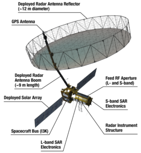
NISAR carries L and S dual-band radar, this observation allows us to see how the Earth’s surface moves across nearly the entire planet. By discovering all data nasa decided it would be stored in the cloud and free for anyone to research.
NASA-ISRO collaboration developed by Earth Observe Satellite is expected to launch by 2025. This radar imaging-based satellite uses dual frequencies. With a total project cost estimated at US$1.5 billion, NISAR would be the world’s most costly earth imaging satellite.
how will the NISAR mission transform disaster management?
The NISAR mission combines high-class radar technology satellites to obtain data. By providing details and early warning scientists may make better decisions and it will help reduce to save life and economic losses.
let me take you through, how the NISAR satellite provides timely accurate, and detailed data for the Earth’s surface….
NISAR satellite is a unique window for Earth This mission
focuses on advanced imaging technology to provide detailed
insights. It observes and measures the earth’s surface.
- Sea label rising: NISAR will provide real-time images of flooded areas cloudy and night-time. It helps disaster response teams identify affected regions and allocate resources effectively.
- Earthquake: NISAR radar technology can penetrate the ground and detect minor shifts in tectonic plates. This data helps scientists identify high-risk earthquake regions.
- Tsunami: By observing coastal areas and tectonic shifts, NISAR tracks underwater earthquakes that cause tsunamis, helping with early evacuation.
- Volcanic-eruption: NISAR will monitor ground deformation near volcanoes, this data helps timely alert nearby populations.
- Landslides: Heavy rainfall often causes landslides. NISAR will monitor land surface changes or help identify and predict landslides.
Why NISAR will be a game changer for climate change studies?
NISAR is more than a satellite. It provides scientists with precise information about the earth’s climate, helping them address the challenges of climate change quickly and precisely.
let me take you through a vital tool for studying the Planet’s changing climate….
- Ice cheet and glacier melting: NISAR will precisely measure ice sheet movement and thickness in the Antarctic and Greenland. This data helps predict the sea-level rise caused by glacier melt.
- Study soil moisture: By measuring soil moisture, NISAR will enhance our understanding of drought patterns and water scarcity.
- Coastal erosion and sea-level rise: true! Because coastal areas are highly risky zones for climate change, NISAR will monitor erosion and flooding caused by rising sea levels or nearby storms and inform coastal areas.
- Urbanization and heat islands: NISAR will study how urban growth can lead to climate change, NISAR will map urban expansion and provide data on how urbanization causes climate change.
NASA & ISRO Collaboration: Why Does NISAR Matter?
NASA’s partnership with ISRO is an essential move for the space community. this mission symbolizes a technology milestone, leveraging the strengths of both organizations it’s the earth’s most pressing challenge.
Join contribution:
- NASA provides an L-band synthetic aperture radar, a high-resolution radar system capable of penetrating vegetation and monitoring the Earth’s surface.
- ISRO developed the S-band synthetic aperture radar, a complimentary radar system optimized for measuring finer surface-level changes.
Importent of collaboration:
- This partnership highlights the shared commitment of NASA and ISRO to advancing earth science for global benefit.
- By pooling resources and experience, the mission achieved cutting-edge technology advancement while reducing costs for both agencies.
- It shows a legacy as a future international collaboration in space exploration and earth observation.
Discovering Earth’s surface with NISAR’s radar technology.
NASA-ISRO joins collaboration NISAR a technological marvel, which is a groundbreaking radar imaging satellite. it’s designed to monitor Earth’s detailed surface observation. let me take through radar technology.
- Synthetic Aperture Radar(SAR): SAR technology uses radar to create high-resolution images of the earth’s surface. It can withstand weather and lighting conditions, and unlike optical sensors, it can penetrate vegetation and surface layers.
- Dual-Band radar technology: NISAR is the first dual-band satellite Its partnership would have a major contribution from both agencies.
- NASA provides L-Band radar with a longer wavelength(24 cm), ideal for large-scale processes like tectonic shift, forest biomass, and ice sheets. NASA would give engineering payloads such as payload data subsystems, high-rate science downlink systems, GPS receivers, and solid-state recorders.
- ISRO provides S-Band radar with a shorter wavelength(12 cm), ideal for studying soil moisture, agricultural monitoring, and coastal changes.
- Application of NISAR technology:
- Earthquake & tectonics: trace crust deformation and predict earthquake zones.
- Ice sheet & glaciers: monitor melting rates and contributing to sea-label rise.
- Agriculture: monitor crop health, water use, and soil moisture.
- Natural disasters: provide data for disaster response to floods, landslides, and tsunamis.
nasa.gov/isro.gov.in
NISAR will launch ISRO’s (Geosynchronous Satellite Launch Vehicle) GSLV mk||. it will launch between 2025 and the mission’s expected shelf life is around 3 years.
We thank you so much for taking the time to read this article. As we promised, we say that we derive data from reliable sources; to check the article’s authenticity, we add all those sources.
Last on the list we thank you again, and we’d love to address your thoughts about this article. what you like and what we can improve please feel free to mail us at (ihrittickdebnath@gmail.com)